 [Summary] [Summary] |
Seashell-hunting and farming: territory-allotments in Ocenebrinae,
on islands off Aunis & Saintonge, western France. |
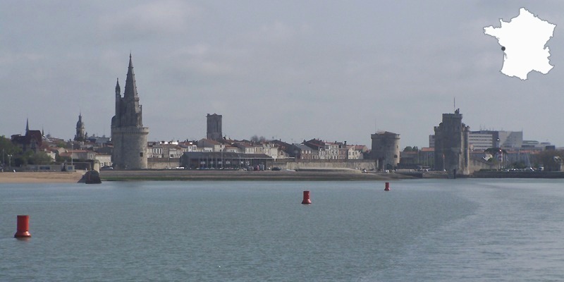 |
La
Rochelle seafront. With more than a millennium behind it, the capital
of the Charente-Maritime owns many ancient buildings. Five can be seen
on this picture; among them, the Lantern Tower, with its sharp-pointed
roof, was used as a jailhouse (many graffiti of hight interest), lighthouse
and landmark. The two forts at right defended the access to the harbour. |
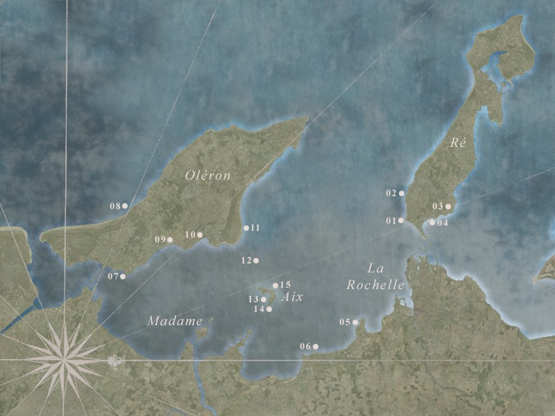 |
Ré and Oléron are two large barrier-islands that protect a wide bay of hight zoological interest (marine mammals, sea turtles). Four rivers waste their sediments here. From south to north (from left to right): the Seudre estuary, the channel of Brouage (invisible here), the Charente river, the channel of the Sèvre-Niortaise, which ends in the harbour of La Rochelle.
The bay communicates with the Atlantic ocean by three straits, named "pertuis": the southernmost is the Maumusson strait, between Oléron and Arvert-Marennes area; the Pertuis d'Antioche separates Ré and Oléron; finally, in the north, the Pertuis Breton between Ré and La Pallice seaport, west of La Rochelle, opens to the famous Aiguillon bay (many Tellinids and seabirds, here). Two small islands, Aix and Madame, are sheltered paradises that deserve to be seen. All the area is invaded by wild mussels and oysters, and is one of the major places for shell-farming in Europa.
01 Pointe de Chauveau: tide-pools.
02 La Jalousie: tide-pools.
03 Les Châteliers: cistercian abbey.
04 Rivedoux: shell-farms.
05 Pointe du Chay: dipping nets.
06 Les Boucholeurs: farmed oyster banks.
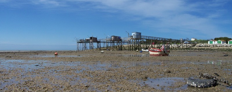
07 Le Château d'Oléron: citadel and mud flats. |
08 Les Vincentes: a reef on the western coast.
09 Oyster-farms of la Baudissière: maturation-ponds.
10 Fort Royer: oyster-bungalows.
11 Les Saumonards: sandy beach.
12 Fort Boyard: a fortress on a submerged reef.
13 Anse du Saillant: oyster parks, bouchots and dipping nets.
14 Coudepont: a growing reef of oysters and worms.
15 Le Jeamblet: wild life on a rocky flat. | |
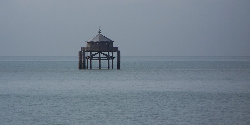 |
The
Lighthouse at the End of the World, off the Pointe des Minimes, at the
entrance of La Rochelle channel, is a replica of the San Juan del Salvamento
building that was inaugured in 1884 on the Isla de los Estados, south
of Tierra del Fuego. This odd hut was said to have inspired Jules Verne,
who wrote the eponym novel in 1905; hence the name of the french copy.
This fake lighthouse sits on an intertidal rocky flat that was discussed
in a previous article (here). |
| |
| Introduction: |
| |
The
bay of La Rochelle is a quiet territory; its turbid waters are brackish
enough to be perfectly adapted to shell-farming. The islands, Madame excepted
(too close to a river mouth) share a noticeable feature: their western
shores are rocky, with an abundant wildlife characterized by the presence
of many dominant species, each one related to a certain depth, while the
eastern sides are severely muddy and colonized, exclusively, by oysters,
mussels, and their satellites. The predators, and among them the Ocenebrinae,
apportion the territories according to this differenciation: O. erinaceus
in the west, P. inornata in the east (with also erinaceus).
One can observe that inornata remains prisoner in oyster and mussel-parks:
the species is unable to spread outside the farms. The reason is a poor
(or absent?) free-swimming larval stage, that forbids any attempt to escape
through the large muddy plains that surround the exploitations. |
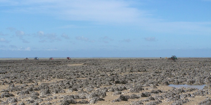 |
Traction engines in the Boucholeurs flats, at low tide, in the southern end of Châtelaillon bay (spot number 06). All the ground is covered by a thick layer of mud in which unexperienced pedestrians can sink and loose, if not their life, at least the boots, and certainly all their insouciance. In fact, shelling here can be an adventure. Do not trust your eyes! |
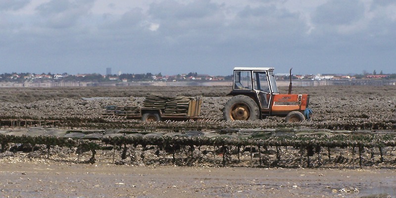 |
A
"plate", used by workers to collect oyster bags and bring them
to maturation-ponds in the hinterland. There are two or three roads in
the park; follow them and you'll be safe. Notice the mirage near the shore,
which builds a cliff where there are only beaches and mud plains. This
is the reason why, sometimes, you will see wonderful tractors flying upon
the oyster beds. |
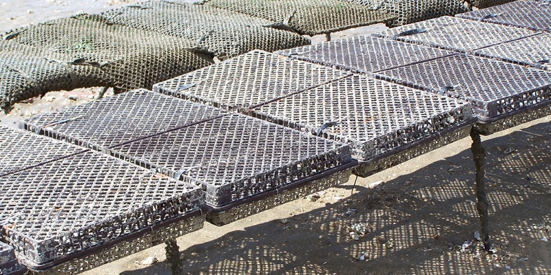 |
Young oysters are kept in these solid baskets. Their meshes are smaller than local Muricids. |
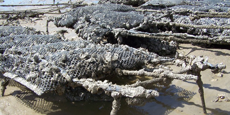 |
Larger shells spend their marine life in these bags, which avoid predation. But there is enough wild oysters everywhere to feed all the Ocenebrinae you want. Below are some examples of the local Japanese Drills. |
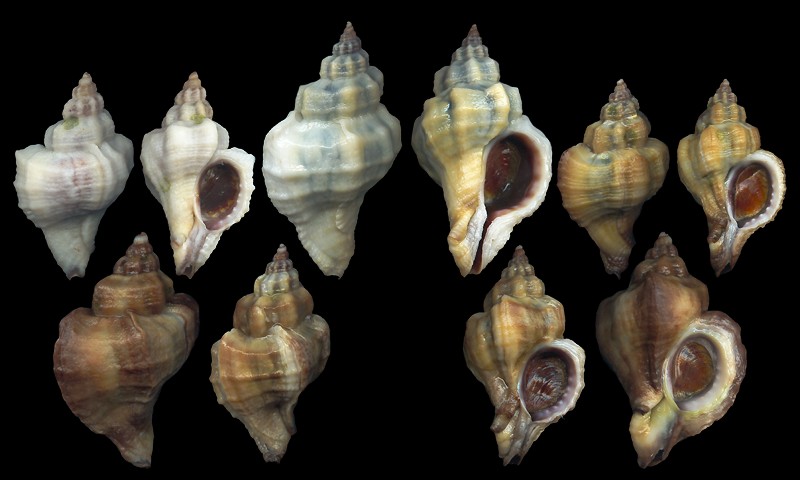 |
Pteropurpura inornata (Récluz, 1851), fished asleep in the mud, among wild oysters on which they fed. 33 to 42mm. Upper intertidal specimens are smaller than average. Ocenebra erinaceus (Linnaeus, 1758), which prefers deeper waters, was absent from the area. A characteristic of the species is this yellow-blueish colour, that erinaceus never shows. |
| Dipping nets: |
| |
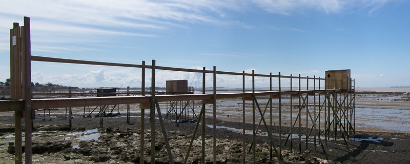 |
Spot 05. Three "carrelets" on the Platerre beach, Pointe des Chirats, Angoulins, northern end of Châtelaillon bay. They are squared nets, laying on the sea-bottom. From time to time, fishermen quickly raise them up, in the idea of catching the fishes that could eventually swim upon them at flood tide. Sometimes, a bait (vernacular term: the "boît") is exposed in the center of the nets. People name the wooden structure by using the same word. These fishing engines are fairly common. |
 |
Same spot. Five specimens near the Belette Point. Each village, each island has its little troop of "carrelets". The same kind of engines, typical of shallow waters in sheltered areas, are found in Adriatic, where they are called "padelloni". |
A last way of fishing will be shown in the further pages : this is a pond, an artificial tide-pool, with some gates for water evacuation, in which the fishes are trapped. The two major islands are surrounded by these ponds, that are called "écluses" by native people. Most of them have their own name: "Basse-ronde", "Providence", "Hirondelle", "la Prée", etc...
Now that this overview is
finished, let's visit the islands, let's admire the sea, the shells, the
boats, and the ponds. |
| Where do you wish to go now? |